Showing posts with label Wessex Ridgeway. Show all posts

Sunday, January 16, 2022

Wessex Ridgeway: Some comments

Although the Wessex Ridgeway is not well known it is a substantial long distance walk over rounded hills and ridges, mainly farmland and with some good views.

Much of the route is on chalk downs, "downs" being the local name hills on this type of rock, typically covered with grass, farmed traditionally with sheep, and with dry valleys, as water sinks into the chalk rather than forming streams. However you could doubt this on the first part of the trail where rivers and streams are frequently encountered, fortunately all with bridges. Only after entering Wiltshire and on the latter half of the route is the landscape more typical of the downs. In good weather the higher ground associated with the chalk gives tremendous views over lower land to the west or north particularly as you walk around the boundary of the Salisbury Plains Military area. Most of the route is over farmland, mainly grass fields but with fodder and cereal crops also cultivated. Areas not farmed are woodland and tree plantations with a variety of species. Raising pheasants and then shooting them is typical of the area, and a popular activity among the country gentry.

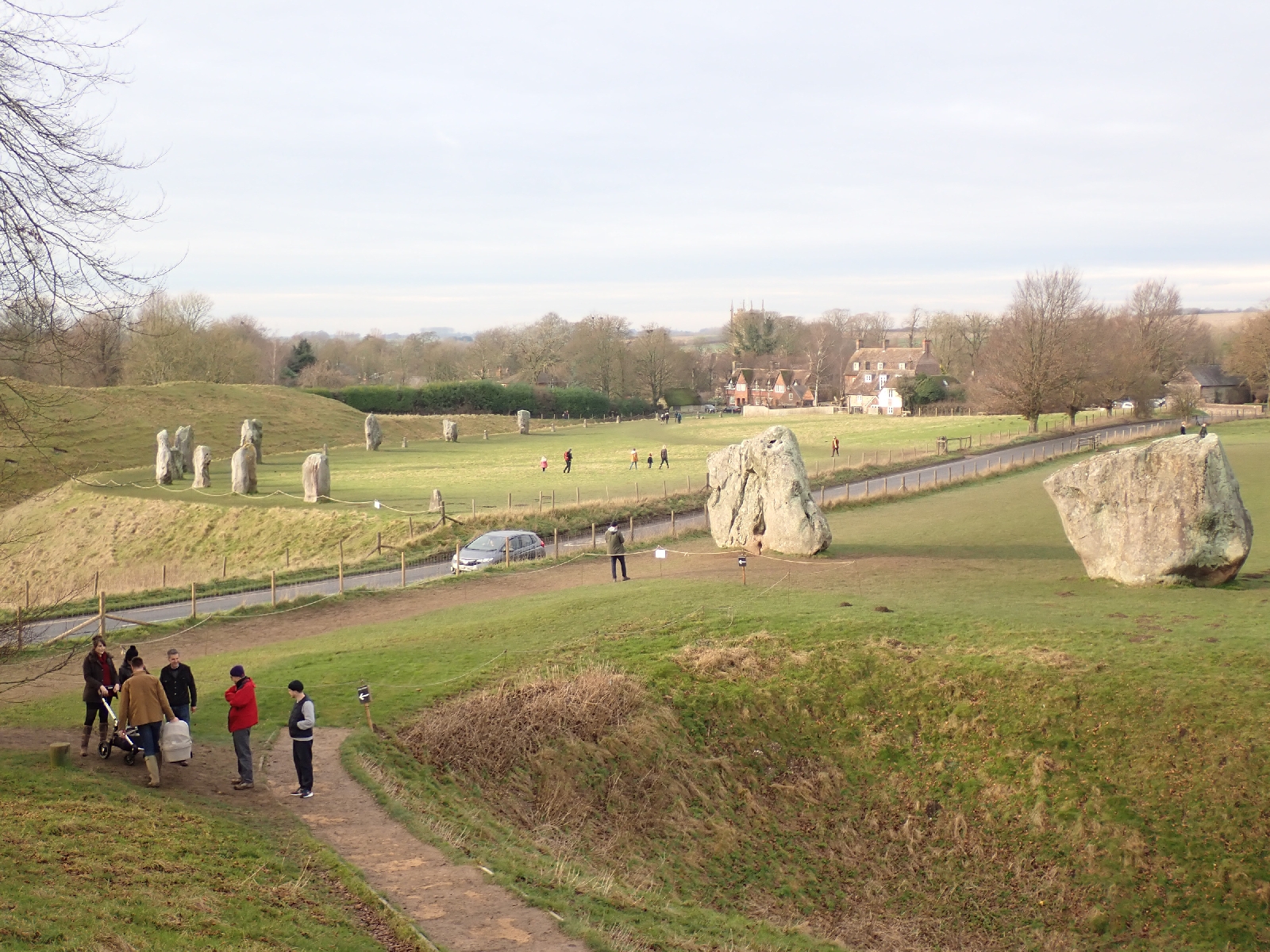
Waymarks, of a green dragon, are common although you need an Ordnance Survey map or a GPS with the track loaded to navigate. The only guidebook is somewhat out of date. As I was walking in January at the ragged end (I hope) of the Coronavirus pandemic a number of places normally offering a bed for the night were closed. Consequently I wild camped two nights. At other times of the year I would expect that you could complete the route using Bed & Breakfast accommodation throughout. Being mainly farmland, the route is not well suited for wild camping. The inns I stayed at most nights were more expensive than I expected, possibly they would be better value with two sharing a room. Food served in these pubs was imaginative and included more varied dishes than just the "Pub Classics" (so not everything came with chips), however this was reflected in the prices. While there was a good selection of hand pulled beers, these now seem to be called "ales", not sure if this means that lager is called beer. Three towns are on the route, Lyme Regis, Warminster and Devizes (four if you walk to the end at Marlborough), and there are several villages. "Pretty" is how one might describe the villages with old thatched houses, buildings of stone or flint, duck ponds, old churches and pubs dating from the time of Thomas Hardy. Yet at the time when that author lived I suspect the villages did not look quite so neat and tidy. Not all villages had a shop, and a pub is likely the only source of refreshments, so some forward planning is needed. Many hill forts are on the route, partly because the Wessex Ridgeway seeks to follow the higher ground with the best views, these were also the ideal places to build a hill fort if you lived in the Iron Age.

January is not the best time to walk this route, although if you are lucky like me the sunny, frosty days are beautiful. Rain and cold should be expected, but need not be detrimental to enjoyment provided suitable warm clothes and water proofs are carried, indeed at times I was overheating when on the move. Mud is more of a nuisance, getting everywhere, dropping off onto clean, light carpets on entering spotless bed & breakfast accommodation. There may still be mud and rain in the springtime however you should also be blessed with an abundance of colourful wild flowers.

I completed the route from Lyme Regis to Avebury in nine days. Maybe not my most dramatic long distance trek but a walk through "England's green and pleasant lands".

Devizes to Ogbourne St George: Greater Ridgeway Day 10

Today I left the Wessex Ridgeway at the famous stone circle at Avebury and began my trek on the Ridgeway National Trail. 

I left Devizes on a straight track, a "ride" between lines of trees just as a grey dawn was starting to seep into the eastern sky. A couple of early runners went by on their Sunday morning jog. Following a road rising up from the valley, then a gravel track, I reached the footpath to my first hill fort of the day at Roundway Down. Good views, if a little misty, from the edge of the ramparts. Fields; a well-attended golf course; an ascent; a descent; a muddy, heavily rutted track, and a climb to the top of Cherhill Down followed, where I reached my second hill fort. Beyond its double banks was an obelisk, a stone needle, called the Lansdowne monument built to commemorate Sir William Petty (I had not heard of him either). According to the map, out of sight below me was another white horse cut into the hillside.

Some of the Ridgeway tracks have been made very muddy by motorbikes and four wheel drive vehicles.

Cows seem to be kept in barns at this time of year.

From there it was down a ridge to Avebury (with a bit of unpleasant walking by a busy road). The stone circle at Avebury is said to be the largest in the world, and is surrounded by a large earth bank. However, the overall effect is rather spoilt by busy roads running through the middle and a village straddling it. Destruction of the large stones for building materials over the centuries has also not helped. Many of the stones are missing, concrete posts mark where they once stood. Remaining stones are large (a few metres in height) and oddly shaped, they did not appear to have been "worked" into neat rectangles. My lunch was at the National Trust café at the edge of the circle with lots of people milling about.

Avebury Stone Circle.

Two avenues of standing stones once led away from the stone circle. Only two remained of the westerly avenue, I walked down the other avenue heading south, where a few more were still standing. When this ended I continued on to where the Ridgeway National Trail started a kilometre or so away in an undistinguished but busy car park. On the other side of the road a circle of stones and timber posts once stood, modern concrete blocks marked their positions. In some way this was connected to the larger Avebury stone circle.

Beginning the Ridgeway National Trail was a milestone on my trip across England, although by joining it I missed the last few kilometres of the Wessex Ridgeway which officially ends in the nearby town of Marlborough. The Ridgeway is much more popular than the Wessex Ridgeway, it helps that it is one of Britain's 15 National Trails and so well maintained. Many people and their dogs were out for a Sunday afternoon stroll, the weather keeping dry. 

Prior to my trip I had watched several videos on YouTube posted by Abbie Barnes, in addition to equipment reviews she describes her trips along various long distance paths, the Ridgeway being one. Two unexpected events happened to me on the first stretch of the Ridgeway; firstly Abbie Barnes was walking towards me, secondly I actually recognised her and said hello (I am usually not good at recognising people out of context). We exchanged a few words and I thanked her for all the videos but forgot to get a "selfie" with her for the blog.

As on the Wessex Ridgeway, I was walking with the chalk downs to my right, somewhere to my left the land dropped away to lower ground, loosing 60 metres in height and giving distant views when my route was near this edge. The track was in better condition than I expected, maybe because motorized vehicles are not allowed on it in the winter, and due to the lack of rain in recent days. I made good progress arriving at Barbury hill fort as the pink rays of the setting sun illuminated its banks and ditches. Three men in camouflage clothing and cameras with enormous lenses were rushing around trying to photograph something. Not sure what, although I had seen a buzzard and red kite so far on my trip.

My efforts to find a Bed & Breakfast or some other type of resting place on this section had failed, the options I had noted in my planning were either closed or not answering their phone. Consequently I was looking for a discrete spot to wild camp, hidden from view for what is technically an illegal activity. Difficult, as I was walking over open grassland on a ridge with no little hollows where I could camp out of sight and there were various discouraging signs. As darkness fell I ran out of options and pitched my tent by the Ridgeway on a patch of grass from which no buildings or roads were visible nearby, only lights from cars streaming along some distant road and houses some miles away. 


Saturday, January 15, 2022

West Lavington to Devizes: Greater Ridgeway Day 9

A shorter day tracking the edge of the Salisbury Plain Military area before dropping down to the town of Devizes.

Mist was prevalent this morning but unlike yesterday when it collected as cloud cover over lower ground, today it was more diffuse, the landscape becoming whiter and features less visible as the distance increased. Apart from a brief period of sunshine the sky was overcast but dry and although I would have preferred a hard frost to freeze the mud it was pleasant enough.

As has become typical of this trip, on leaving the village where I enjoyed the night I had a climb back up to the edge of the plateau. There I rejoined the gravel road that follows the boundary of the Army's land. This gave fast and straight walking for several kilometres with misty views in washed out colours to my left, beyond the plateau. I noticed a cross with German writing, a memorial to Dirk Jager Knöffel, a visiting paratrooper who died in 1993 when an anti tank vehicle rolled over. A faded wreath of poppies lay at its base.

Gravel road beside Salisbury Plain Military area.

Urchfont duck pond, church in the background, a view typical of many villages I walked through.

Leaving Salisbury Plain and the Military ranges behind I turned left and entered the views I had been admiring, walking down to the village of Urchfont. A place of red brick houses from the 16th and 17th century with the traditional duck pond, church and pub. Many of the settlements I had walked through appeared to have few facilities or living people. Urchfont was different in that it had a community shop housing a post office. A group of people were chatting outside, motioning me to go in ahead of them. Run principally by volunteers, I was pleased to buy a cup of coffee and a Kitkat for my elevenses. I drank it outside watching people arriving to pick up their morning paper. Being Saturday I frequently passed people, mainly runners, cyclists and dog walkers with their smart looking Jack Russells or hyperactive spaniels, balls in their mouths, but a few family groups were enjoying an outing together. 

On the last little section of my route, I noticed a large group of crows (technically a "murder" of crows) gathering on the stubble of a nearby field. As if undecided, some of the birds periodically landed and took off again until they finally settled. Approaching the outskirts of Devizes, tired of the mud, I detoured to avoid a section that looked especially muddy, and followed a quiet road instead. Then the towpath of the Kennet & Avon canal lead me to the town centre. As a place I have visited twice before I can recommend a visit to the Caen flight of locks on the canal and the Wadworth's brewery tour if it is still running (especially the informative tasting at the end, do not plan to drive afterwards)! My room at the Black Swan Inn overlooks the busy market square. Inevitably bits of mud fell off my boots and over-trousers onto the pale, oatmeal carpet, and I spent some time trying to pick them up. Now having shopped, showered and washed clothes I am enjoying the comfort of my room while I can. I expect to spend the next two nights wild camping as I am struggling to find alternative accommodation open or answering their phone.

Friday, January 14, 2022

Warminster to West Lavington: Greater Ridgeway Day 8

Another fine day, walking around the edge of Salisbury Plain looking down on the cloud covered lowlands.

Not as cold this morning so the frost was confined to the shadows of hedgerows. After a late start due to a bit of shopping I climbed out of the provincial town of Warminster, by a golf course already busy with groups of men and their equipment. Looking back the view of the hills I had crossed yesterday was stunning, they looked like headlands into a sea of white mist reflecting the sunlight. 


Salisbury Plain Military area.

For most of today's hike I had the plateau of Salisbury Plain on my right. A military training area, frequent signs warned me to keep out. Although farmed there were no signs of any settlements. On my left the land dropped away, a steep slope somewhere nearby. I stood in clear blue sky but looking down the view was of a white sea, in which islands of land or the tops of trees were periodically visible. At one spot everything beneath me was concealed by cloud, then the cloud thinned and the town of Westbury miraculously appeared. Nearby was a large deep pit where the chalk had been quarried. Someone thought it had some recreational use, subtly changing the signs so they appeared to say they were a "play area".

Sign on a quarry slightly disfigured with red paint so as to change its meaning.

On the chalk hills that I am following on this trip a number of white horses have been cut into the hillside. These representations have been created by removing the turf to reveal the white chalk beneath. Today I stood above the Westbury White Horse, based on one originally created in the late 17th century. To avoid the task of keeping it white by periodically clearing soil and vegetation as nature tries to recover the rock, this "White" horse has been rendered in concrete, that might once have been white, but has now weathered to insipid, greyish tones. Not as impressive as those in which the chalk is exposed. Above the white horse there were the banks and ditches of another iron age hill fort, the steep slope below makes it an obvious defensive location. 

Westbury "white" horse.

Long, straight tracks surfaced with crushed stone and grass covered bridleways led me through a green landscape softened by the warm light of the low winter sun. After a long descent I arrived at my lodging for tonight, a small apartment. Money was taking from my card on booking with an App, an email followed with the code for the key safe. In this way I was able to enter and make myself at home without having to speak to or bother anyone. Sign of the future?

Thursday, January 13, 2022

Hindon to Warminster: Greater Ridgeway Day 7

A leisurely day, frosty at first and sunny throughout. One church, two hillforts and an army camp.

Leaving the Inn full of breakfast I walked up the street between pollarded trees and well-presented, old brick and stone houses. Turning into fields I was struck by the sight before me, all the grass and hedges were coated in sparkling white frost, as if painted by the winter fairy. Blue skies and sunshine added to my feeling of contentment and best of all the mud had frozen. For the first hour of my hike my feet crunched on white "icing" that had yesterday been a brown slurry. I was reminded of those chocolate truffles with a hard chocolate casing which you crack to meet softness inside. Lines of mist blanketed distant low lying landscape, reflecting white in the winter sun. Weather is not in your control, and on a long distance walk you have to deal whatever it sends you, so a frosty, sunny, still, blue sky day in January is a joy to be cherished while it lasts. 


With such thoughts I crossed fields, the busy A303 road, another field and then entered an extensive forest. Tracks were mainly good as I walked among the pines, birch and larch. At the edge of a village a large, blue "Thank you NHS" sign, attached to hay bales reminded me that the Coronavirus pandemic continued to restrain us with its cold and sickly hand.

I followed a river into the village of Haytesbury thinking of God, things we cannot control, and a little Serbian monastery I had visited one Easter. With such thoughts it seemed natural to visit the village church. A handsome affair at its best with the sun's light reflected off the white stonework. Inside I disturbed a lady with a vacuum cleaner who soon left me in peace to admire the chancel and read of its Norman foundation and many later changes.

Church of St Peter and St Paul, Heytesbury.

Climbing out of the village the next section of the walk was along the high ground beside a wide valley. My route followed the boundary of the Army's Imber firing range, part of the large area of land on Salisbury Plain used by the Military for training. Military activity was not knew to the area, I walked around the sizeable earthworks of Scratchbury and Battlesbury iron age hill forts. With the surrounding steep slopes they would be easy to defend and had commanding views over the nearby valley. Middle Hill, between the two had a tumulus, a bronze age burial mound sprouting trees. There were several people out walking across these summits, more than I seen on previous days, maybe the sun and scenery had brought them out.

Scratchbury hillfort.

Returning to lower ground I walked by a Military camp with somewhat superfluous signs warning of the razor wire fencing they were attached to. Among the Army housing there was a NAAFI where I bought cup of coffee from a machine. 

Although I have driven around Warminster many times this is the first time I have been in the town centre. I had wondered if the town's name was related to the nearby military establishments but the guy on reception at the inn said no, although he said there was a military college here. Wikipedia suggests the "War" in Warminster comes from the River Were which runs through the town.

Wednesday, January 12, 2022

Ashmore to Hindon: Greater Ridgeway Day 6

Today the sun infused the landscape with colour. 

Waking in my tent this morning I was surprised it was not colder as temperatures approaching zero were forecast. Maybe the decaying leaves I was camped on in this ragged wood were keeping me warm, because walking by open fields in the hour before dawn, sparkling, white frost on the grass's leaves reflected the light from my head torch. Ice had welded gate latches together and made the wooden stiles very slippery, I crossed them slowly, cautious like an aged gentleman nervous that a foot might slip.

The lights of distant towns floated in the blackness beneath the constellations of stars. I walked through Ashmore in complete darkness. These small villages do not merit streetlights but lights were appearing at bedroom windows as people began their days unaware of my passing beneath them. I admired the reflection of a lighted kitchen window in the duck pond. On leaving the houses behind, stirring from their slumbers, stripes of red, orange and blue appeared on the horizon, silhouetting the trees and hedges I was walking by. Skies were clear except for some thin wavy bands of pink cloud and the decaying lines of vapour left by passing aircraft. 


Royal Tollard seemed another pretty village of prosperous people when I crossed it in the half light. Details on the Ridgeway waymarks, now a darker shade of green, indicated I had left the county of Dorset and was now in Wiltshire. As light filled the sky I rambled up a long dry valley, mainly of grass. Dry in the sense that it contained no stream or river, a typical feature of chalk landscape but one I had missed on my muddy walk so far. My route led onto an estate with dotted trees on the valley floor and woodland on higher slopes. Notices made clear that all was private outside the line of the footpath (although at least they made clear with arrows where the footpath went).

Climbing up through the trees I reached the bald ridge of Win Green. From the top views were extensive beneath the clear sunny skies. Fields, woods and small settlements draped over undulating land. I continued on my way admiring the catkins, which my father told me were a sign spring was coming, and a still lake faithfully reflecting the blue skies and trees beyond.

Old Wardour Castle looked at its best with the sun shining on the white stone of its ruined walls. Sadly closed weekdays I could not visit its tea shop so continued by a blacksmith's forge to New Wardour Castle, an impressively large stately home in the Palladian style now split into separate apartments. In the grounds were some interesting trees but leaving the estate proved difficult. Two ladies with fur hats helped me by pointing out the button I had to press to open the gates.

Old Wardour Castle.

A few words on the farmland I was passing. Most of the fields were grass which looked a healthy green in today's sun, but being winter the sheep were feeding on turnip (both the green leaves and the ploughed up roots it seemed) which seems to be widely planted. Temporary electric fences were used to keep the sheep in one section of the turnip field. The cows I saw were in sheds being fed on hay, no doubt cut in the summer. There were also stands of maize, but the corn cobs seemed to have been left for the pheasants, of which there were many. I also passed the stubble of some kind of grain crop. Tiring I sat on a metal bench with the name Harold cut into the metal back. There was even a flat cap hanging on the back, made of metal. An excellent spot to enjoy some lunch with a view spread out before me.

I was glad to reach Hindon and the Lamb Inn, the destination for my tired legs (a notice on the door claimed it a "Good Shoot Hotel", a sign shooting game birds was a popular pastime in the area). I was less happy about the mud I brought in despite taking off my boots and over-trousers at the door. However I was not the only culprit, marks ahead of me on the hall appeared to be muddy paw prints. Why oh why do hotels insist on light coloured carpets!

Tuesday, January 11, 2022

Ansty Peck to Ashmore: Greater Ridgeway Day 5

Another muddy, misty day, possibly obscuring magnificent views.

After leaving my Bed & Breakfast I rejoined the Wessex Ridgeway at a muddy track. It was so wet a stream occupied a section of it. By balancing on the bank between brambles and water, supported by my trekking poles, I maintained a grip where slip marks showed others had failed and manged to edge passed this obstacle. Next, my first steep climb of the day to the top of Bulbarrow hill and its hillfort. The earth works were of a decent size, an impressive defence to anyone out of breath climbing the hill. There was a mound on which someone had planted a large cross, maybe to exorcise any pagan worship that once took place here. I reached the cross through a gate marked "Private - No Right of Way" despite it being a public footpath (I confirmed this on the Ordnance Survey map on my OutdoorsActive App). From here the route was along a ridge on a tarmac road. Sadly mist obscured the views but a passing cyclist assured me they were magnificent. 

Typical path.

A good path on compacted stone led me to woodland, then a descent to the village of Shillingstone. The sunken path down had an abundance of harts tongue fern on its sides, green among the dull browns. My research had indicated there was a tea shop at Shillingstone which I was looking forward to patronising, but worried that my boots, trousers and much else was far too muddy to be allowed in. I need not have stressed, the tea shop was closed.

After a snack on a wet bench in the café and shopless village I followed the path over fields on a flood plain, crossing the river, walking by a farmyard, its concrete yard coated with brown slurry. Then the inevitable climb, a steep one up towards Hambledon Hill. Although the Ridgeway does not quite reach the hillfort that sits on top of this flat topped hill, the parallel earthworks were clearly visible on the side of the slope, at least when not hidden by passing clouds. 

Hambledon Hill showing the banks and ditches of the hillfort.

A few more hills were crossed which included dropping into Iwerne Courtney on a white chalk track, another village without a shop or café. Towards the end of my day I began skirting or crossing extensive areas of woodland. My plan was to camp in these woods but initially the many "Private Woodland" signs and fencing discouraged me. The area, with its neat thatched cottages and Audi cars, was evidently prosperous, but the plethora of "Private" signs suggested wealth was not compatible with a willingness to share. Eventually I reached woodland that was not fenced or ringed with warning signs. I found a spot free of brambles, partially hidden by fallen trees on which to pitch my tent as darkness fell. Now lying in my sleeping bag surrounded by darkness I am listening to two owls, one near and one far away, calling to each other. A pheasant's screech periodically intrudes. 

Camping in the woods.

Monday, January 10, 2022

Sydling St Norman to Ansty Pleck: Greater Ridgeway Day 4

A day of grey trees gradually appearing through the mist.

Trying to get everything into my rucksack has proved a strain this trip. Other hikers walk the length of the Caucasus with a 35 litre rucksack whereas I have trouble squashing everything into one of 60 litres. Risking the stitching or splitting my tube of toothpaste (I have done it before) I pushed the contents down hard to make space for one more item. I managed last summer, but my winter sleeping bag and other items included should the weather cool to freezing, are a bit more bulky.

Leaving the picturesque village of Sydling St Norman after noting its thatched, tiled, slated and flagstone roofs, I climbed steeply up to the ridge. Ghostly in the mist, sheep were feeding on turnips in a wintry scene. They gazed at me from behind a temporary electric fence. There was a section of good track, straight and floored with flints that took me north by green pasture. Turning east across an open field of stubble the grey whiteness of the mist enveloped me, hiding all but my immediate surroundings. Slowly a stand of trees became visible before me, their greyness gradually darkening as I approached. Dropping down into a valley, and below the main body of cloud, I could see more distant objects, but not the giant man of Cerne Abbas. This figure, created on the hillside by some earlier generation who dug up the turf to expose the white chalk beneath to outline the figure of a well endowed man, was either not visible from the route of the Wessex Ridgeway or the mist was hiding it. 

A good straight path.

Trees appearing through the mist.

The small settlement at Up Cerne consisted of picture perfect, thatched houses with walls of flint with lines of red brick. Their hedges were neatly trimmed (but not in entirely straight lines). Inside a small wooden shelter was a dry bench on which I rested, such opportunities being rare in the wet landscape. Maybe it had once been a bus shelter before the residents owned cars. As I ate a "Twix" I read the notices pinned up offering massage, dog grooming, carpentry (sash windows a speciality) and a warning not to leave items in cars. I read the lead item in the church newsletter slipped behind a notice which greatly saddened me. The vicar expressed the view that most of his sermons "completely passes most of you by" and wrote the spark of hope "dwindled in me too"...

With these melancholy thoughts I climbed out of the valley, the effort required by the steep slope pushing other thoughts aside.

Up Cerne, picture perfect except for some moss on the thatched roof.

After more miles, disturbing squawking pheasants, crossing lonely fields, walking through hedge and tree lined paths, I reached the Dorset Gap, a location where five trails meet. Inside a plastic box there was a book to write messages in. People recorded their walks from nearby villages, their plans to return to a pub for a good lunch and their joy at a fine, winter day (although not today). Soon after I diverted off the Ridgeway trail to go to my Bed & Breakfast,  but not before admiring a line of trees. 

Trees in the mist.

That evening I walked through the darkness to the Fox Inn, the drizzle reflecting the light from my head torchlight back into my eyes. Water droplets danced in front of my head torch as I walked, collecting on my glasses so that I had difficulty seeing. I feared the Inn might be closed, and certainly thought it would be empty on a Monday night in this remote location. I was wrong. Tonight was quiz night and the bar was crowded with an older, country crowd in green and brown coats and a few flat caps. I decided on pheasant for dinner in recognition of the number I had disturbed today. 


Sunday, January 9, 2022

Lewesdon Hill to Sydling St. Nicholas: Greater Ridgeway: Day 3

An early start watching the sun rise over the hills, followed by a day along roads, tracks and paths across green fields, no rain but often muddy.

Although the wind shook the trees, its force eased overnight so the pegs of my tent were undisturbed. Indeed, it had advantages as despite waking to rain drops at one point in the night, the breeze had dried my tent by the time I packed up this morning. 

My accommodation for tonight is at an Inn which closed after lunchtime, so I was keen to make an early start. Leaving my camping spot at 6:00 am, well before any light was in the winter sky, I made my way eastwards, patches of stars visible in the moonless sky. Initially I slithered on a muddy path through trees, glad of my trekking poles for support, later I crossed an open hillside of grass. As I approached its summit the first pink light of dawn was appearing above the distant horizon making a silhouette of the trees on the brow of the hill. Looking down into the valley beyond, spots of lights gathered to outline the nearby town of Beaminster. The lights of other, more distance towns, were visible in the blackness to the south. Helped by the light that precedes the rising sun I found my way down the wet grass to enter Beaminster. Its centre looked attractive with a square surrounded by small shops including an open Coop where I purchased supplies, including pastries for breakfast which I ate on a bench watching the handful of people who came and went.

As I climbed out of the town, the round white sun itself was rising over the hillside. The route took me up an unmetalled road, so old it had sunk into the hillside as a result of centuries of traffic going up and down. I climbed a few such tracks today, their sides green with ferns and ivy climbing the leafless trees. Mud made some unpleasant but in others, water had flowed down these roadways, clearing the mud and leaving pebbles of flint. Occasionally erosion had penetrated deeper, reached the bedrock, washing clean the white chalk in deeper groves. 

A sunken lane lined with harts tongue ferns and ivy.

Not all tracks were so pleasant, one across high ground was not only muddy, there were large pools of water. One proved particularly difficult to walk around as the track was bounded by a thick and brambly hedge on one side and barbed wire on the other. Water rose over the top of my boots and I swore as it trickled down my socks. Nevertheless the views were expansive across the surrounding downs, especially attractive when the low morning sun picked out the folds of the landscape, warming the greens, turning trees from black to brown and highlighting the sheep as they stared towards me. A few sections of woodland made a pleasant change from wet fields but would look much better with spring flowers. 

Sheep on the downs.

In a few valleys there were duck ponds by posh looking houses. Today as well as yesterday, "Private" notices jostled with public footpath signs. A group of motor cyclists drove by me on a rough track, out enjoying a Sunday run, their noise intruding into the peace of the countryside. I passed through a number of small settlements and admired their houses, invariably old. Some were built of a pleasant, rough, yellow stone, sometimes mixed with sections of a whiter stone, cut with a smooth surface into rectangular blocks. There were also old brick houses and at Maiden Newton the use of flint as a building material started, often mixed with courses of red brick. Maiden Newton not only had interesting buildings but also an open village shop, a closed coffee shop and a shop at the Petrol station where I bought a tuna and cucumber roll (chosen as it was the only offering with fruit or vegetable in it) and a coffee.

Then after some walking on a very straight single track road and a very muddy track I reached Sydling St Nicholas. I checked into the Greyhound Inn and after inadvertently depositing mud with my clothes on the carpet of my room, I quickly washed my hands and headed for the bar for a very late Sunday lunch (or as I saw it, an early diner). They kindly kept the kitchens open long enough for me to enjoy a traditional dish of roast beef, roast potatoes and vegetables. Only later did I wonder what had happened to the Yorkshire pudding.


Saturday, January 8, 2022

Lyme Regis to Lewesdon Hill on Greater Ridgeway: Day 2

A wet day crossing muddy fields.

The day did not start too well as I cut my big toe manoeuvring myself between the shower screen and the toilet. Not quite sure how I managed it but the pain was severe, disproportionate to the injury. I applied Savlon and a plaster to the bloody toe and fortunately my recently purchased boots kept it dry despite to the amounts of mud and water I went through today, so I am hoping it will heal quickly.

As I sat eating my breakfast I watched waves breaking over the Cobb with great sprays of white foam. Rain fell for much of the day at varying intensities and wind buffeted me on more exposed stretches. Such weather must be expected in January and I was well prepared, engulfed in waterproofs as I passed local dog walkers on leaving Lyme Regis on a path beside the River Lim. While the trees beside the river were bare of leaves, ferns provided vivid greens on the river banks and later when I walked through woodland. Leaving the dog walkers behind I climbed up my first hill over water saturated pasture. This set the pattern for the rest of the day, climbing up and down hills, squelching through muddy grass. Navigation was by peering at a prepared track on my GPS, but I was greatly assisted by Wessex Ridgeway waymarks, illustrated by a green dragon, more than I expected for a relatively unknown trail.

Waymark.

View from Lambert Castle Hillfort.

After a few hills and a little woodland on paths, tracks and quiet roads, I reached my first hill fort, Coney Castle. Lambert Castle hill fort followed soon after. Earth ramparts were visible but not that impressive, but the hilltops gave pleasing views over green, hedge lined fields, although rain dulled the colours with a grey wash. On Lambert Castle I was chased by a bevy of dachshunds who showed more interest in me than the cries of their owner. Later a small, solitary deer crossed my path but pheasants were the most common sighting. Shotguns sounded around one valley on a Saturday "shoot". A "country set" couple past with a dead bird hanging from the man's hand.

If I had given it some thought I might have short cut a section of the Wessex Ridgeway path where it deviated to the north only to turn back south again. However it did lead me to a fine section of ridge walking, more what I expected from a Ridgeway path, and made more appealing by light from the setting sun appearing below the clouds.

Finally a little late sun on the ridge I was following.

Pilsden Pen was my third hill fort of the day, and with high banks it looked the most impressive, however the skies were darkening with the onset of night and I hurried down. Forced to use my head torch, the path was often difficult to find. The thin crescent of the moon gave little light even when it was not hidden by clouds. An alternative route via roads was easier to follow in the darkness so I missed a short section of the official trail through fields. When I left the road it was to climb up a dark track flanked by trees and banks. Although easy to follow it was very muddy in places so I veered off onto drier land to the right. Soon my GPS showed I was leaving the trail altogether and climbing up Lewesdon Hill on a narrow path. Reaching the boundary of National Trust land I found a patch of reasonably flat, dry ground on which to pitch my tent. As I began its erection, a sudden gust of wind tugged at the canvas pulling out the peg I had placed to stop the tent blowing away. Successfully manhandling it back into position I drove in a few pegs as fast as possible and soon had the tent up, although my haste and the continuing gusts of wind gave it an odd shape. After eating the provisions I had bought for my tea, plus a slice of Auntie Muriel's tea loaf, I put as much as possible back in my rucksack. If the tent blew down I wanted to be able to recover all my possessions without any losses in the confusion of collapsed canvas. Now settled down, my feet warming up nicely in my sleeping bag, I am hoping such precautions are unnecessary.

Friday, January 7, 2022

Lyme Regis: Start of Wessex Ridgeway: Day 1

Today was spent travelling to Lyme Regis, famous for fossils and its literary associations.
I peered through heavy rain as my train to Axminster crossed my planed route on the Wessex Ridgeway twice. My impression was of low hills, green fields edged by hedges dotted or lined with trees, naked, bare of leaves, their black contorted branches exposed to the winter winds. On higher ground there was more woodland than I expected. More rain lashed the bus from Axminster to Lyme Regis, its windscreen wipers beating furiously.

Lyme Regis is famous for the Ichthyosaur found by Mary Anning among the grey rocks, but another more common fossil was outlined on lampposts and shops, the humble but curly ammonite. Unlike most of my planned walk the cliffs here are of grey Jurassic Blue Lias rather than younger white Cretaceous chalk, which I will be walking on for the next few weeks. Lyme Regis' other claim to fame is its appearance in "Persuasion" by Jane Austin, when Louisa injured herself jumping down from the steps of the Cobb, a stone breakwater which creates a calm harbour for boats to moor in. The Cobb also appears in John Fowles' book "The French Lieutenant's Woman". I viewed it in the dusk, after the rain had ceased, with clouds rolling across the horizon. A sign warned of slippery surfaces, no doubt hoping to prevent another meeting Louisa's fate. Romantically, a couple stood looking out from the top of the Cobb into the distant seas, or else at the black suited, early evening surfers hoping to catch a final wave. I walked gingerly onto the top of the wet, rough masonry blocks of the breakwater, making small steps to be sure I did not slip, a dog and its owner strode past me. Being winter dog walking hour, the time before it becomes too dark to be out even with brightly flashing dog collars, there were several owners walking their charges beside the sea, no doubt glad of a break in the rain. At the landward end of the Cobb the RNLI (the Royal National Lifeboat Institution) was keeping abreast of modern trends with a device for accepting donations from contactless Credit or Debit cards. I tapped my card just in case I ever needed help.
Couple on the Cobb at Lyme Regis, the black spots in the water are surfers.

Lifeboat with old and new methods of making donations.

The narrow streets of Lyme Regis are very attractive with a variety of small shops, many selling fossils and crystals, others offering fish and chips. I stopped at a microbrewery down an alleyway for a quiet pint as evening turned to night. Weather forecast for tomorrow, my first day of walking is not so good.....

Greater Ridgeway also known as the Great Chalk Way: Some Comments

The Greater Ridgeway Way crosses England from Lyme Regis on the south west coast of England to Hunstanton on the east coast. Four trails co...