I left Devizes on a straight track, a "ride" between lines of trees just as a grey dawn was starting to seep into the eastern sky. A couple of early runners went by on their Sunday morning jog. Following a road rising up from the valley, then a gravel track, I reached the footpath to my first hill fort of the day at Roundway Down. Good views, if a little misty, from the edge of the ramparts. Fields; a well-attended golf course; an ascent; a descent; a muddy, heavily rutted track, and a climb to the top of Cherhill Down followed, where I reached my second hill fort. Beyond its double banks was an obelisk, a stone needle, called the Lansdowne monument built to commemorate Sir William Petty (I had not heard of him either). According to the map, out of sight below me was another white horse cut into the hillside.


From there it was down a ridge to Avebury (with a bit of unpleasant walking by a busy road). The stone circle at Avebury is said to be the largest in the world, and is surrounded by a large earth bank. However, the overall effect is rather spoilt by busy roads running through the middle and a village straddling it. Destruction of the large stones for building materials over the centuries has also not helped. Many of the stones are missing, concrete posts mark where they once stood. Remaining stones are large (a few metres in height) and oddly shaped, they did not appear to have been "worked" into neat rectangles. My lunch was at the National Trust café at the edge of the circle with lots of people milling about.
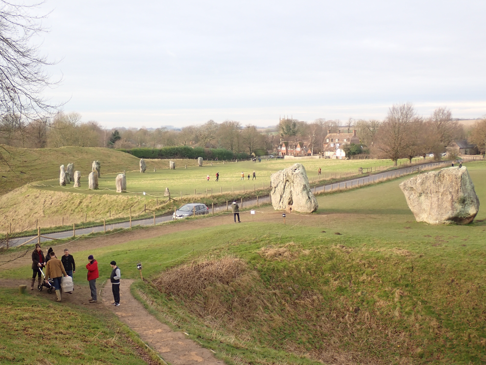
Two avenues of standing stones once led away from the stone circle. Only two remained of the westerly avenue, I walked down the other avenue heading south, where a few more were still standing. When this ended I continued on to where the Ridgeway National Trail started a kilometre or so away in an undistinguished but busy car park. On the other side of the road a circle of stones and timber posts once stood, modern concrete blocks marked their positions. In some way this was connected to the larger Avebury stone circle.
Beginning the Ridgeway National Trail was a milestone on my trip across England, although by joining it I missed the last few kilometres of the Wessex Ridgeway which officially ends in the nearby town of Marlborough. The Ridgeway is much more popular than the Wessex Ridgeway, it helps that it is one of Britain's 15 National Trails and so well maintained. Many people and their dogs were out for a Sunday afternoon stroll, the weather keeping dry.
Prior to my trip I had watched several videos on YouTube posted by Abbie Barnes, in addition to equipment reviews she describes her trips along various long distance paths, the Ridgeway being one. Two unexpected events happened to me on the first stretch of the Ridgeway; firstly Abbie Barnes was walking towards me, secondly I actually recognised her and said hello (I am usually not good at recognising people out of context). We exchanged a few words and I thanked her for all the videos but forgot to get a "selfie" with her for the blog.
As on the Wessex Ridgeway, I was walking with the chalk downs to my right, somewhere to my left the land dropped away to lower ground, loosing 60 metres in height and giving distant views when my route was near this edge. The track was in better condition than I expected, maybe because motorized vehicles are not allowed on it in the winter, and due to the lack of rain in recent days. I made good progress arriving at Barbury hill fort as the pink rays of the setting sun illuminated its banks and ditches. Three men in camouflage clothing and cameras with enormous lenses were rushing around trying to photograph something. Not sure what, although I had seen a buzzard and red kite so far on my trip.
My efforts to find a Bed & Breakfast or some other type of resting place on this section had failed, the options I had noted in my planning were either closed or not answering their phone. Consequently I was looking for a discrete spot to wild camp, hidden from view for what is technically an illegal activity. Difficult, as I was walking over open grassland on a ridge with no little hollows where I could camp out of sight and there were various discouraging signs. As darkness fell I ran out of options and pitched my tent by the Ridgeway on a patch of grass from which no buildings or roads were visible nearby, only lights from cars streaming along some distant road and houses some miles away.

No comments:
Post a Comment